After several weeks of reconnecting with friends and family, and enjoying simple luxuries such as hot showers and a soft bed (not to mention Kristen’s mom’s cooking!), we had begun to feel like we had semi-normal lives again. The emphasis should be placed on the word semi here, because while we were certainly more sedentary, we still were not working. This fact prompted us to feel a wee bit of guilt as Kristen’s parents worked at their respective jobs during the day while we attended to the logistics of being on the John Muir Trail for nearly three weeks. The dreamlike quality of our current lifestyle is always somewhat tempered by the future prospect of returning to a “normal” life schedule of work, obligations, bills, etc. But the immediacy of the thru-hiking challenge allowed us to focus on the task at hand: organizing food and gear for three weeks of foot travel through 225 miles of the highest terrain in California’s Sierra Nevada mountains from Yosemite to Mount Whitney.
Our plan was to drive down to Bishop, and on the way detour up to Yosemite to secure a wilderness permit and bear cannisters, leave a food cache on the trail at Reds Meadow near Mammoth, and then eventually to hike out over Bishop Pass from the JMT to resupply where we would leave our van. We’re lucky to have some great friends in Bishop, Darren and Sarah, who graciously offered to let us park at their place, in addition to using the much needed laundry/bathroom facilities. We felt in pretty decent physical shape from our activities returning from Alaska, and were accustomed to shorter backpack trips of 3-5 days. On a longer trip such as the JMT, food weight becomes especially important, so we had purchased a number of freeze dried meals. Even so, our packs weighed in at ~45 pounds with water and food for 10 days.
We took public transportation from Bishop to Lee Vining, just east of Yosemite, early on the morning of September 6. The aspen had not yet begun to turn, and the landscape seemed incredibly green as a result of last spring’s massive snow storms. Figuring that we had some built up Karma from picking up hitchhikers all over Alaska and western Canada, we tried our luck thumbing up to Tuolumne Meadows from Lee Vining. Without much effort on our part, a quartet of young German tourists returning from Burning Man kindly provided a ride; I tried to be tour guide as best as I could, pointing out all the sights they should check out on the map. Although the traditional start of the JMT is at Happy Isles, we decided to start in Tuolumne Meadows, avoiding the zoo-like atmosphere that usually characterizes the urban wilderness of Yosemite Valley in summer. I surmise that if Muir were still alive today, he would also avoid the valley to hike the premier Sierran trail that bears his name.
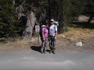 |
| Starting at Tuolumne Meadows |
The first day took us up the Lyell Fork of the Tuolumne River, which occupies a massive u-shaped valley about 10 miles long. The mixed coniferous forest, composed primarily of lodgepole pine, eventually gave way to spacious, green meadows with trout lazily swimming in beautiful stretches of crystal clear river. A healthy looking four point buck sauntered about, not too disturbed by our presence. As we progressed up the valley, granite slabs gave way to steep, forested slopes that led to the towering ridges of Kuna and Koip Crests, as well as Mts Lyell and McClure at about 13k feet. We camped just below Donahue Pass, crossing it the next morning, as we made our way to our cache at Red’s Meadow. The pass was snow free, except for a few snow patches, and the trail beyond descended past some beautiful lakes, including Thousand Island Lake, Garnet Lake, and many others. We spent our second night near Shadow Lake, a glassy lake perched on the edge of a granite bench. Here we noticed some of the unfortunate impacts of thousands of people using the trail over the season… unvegetated, trampled stream banks and other cleared areas. The ranger had informed us when we obtained our permit that there had been a 300% increase in use on the JMT; a blessing in the form of more potential wilderness advocates, but a curse in the form of habitat damage along the trail.
 |
| Lyell Fork of the Tuolumne River |
 |
| Mt Lyell high above the valley |
 |
| Donahue Pass with Banner Peak and Mt Ritter in the background |
 |
| Spring wildflowers in September! |
 |
| Thousand Island Lake and Banner Peak |
 |
| Shadow Lake |
The following day we completed our descent to Red’s Meadow, passing through Devils Postpile National Monument, where glaciers had ground columns of basalt, creating a table top mosaic of hexagonal shapes thousands of years ago. The weather had been fantastic up to this point, but began to change to thunderstorms as we picked up our food cache. Fortunately, our cache had not been tampered with in the bear box at the campground where we had left it three days before. It took more than an hour to sort and repack all our food for the next nine days. As we shouldered our now heavy loads, thunder clapped and boomed overhead, and a light sprinkle began to fall.
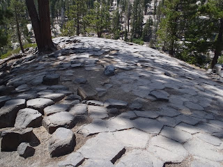 |
| Hexagonal basalt columns at Devils Postpile |
From Red’s Meadow we detoured from the JMT which hugs the western slopes of the Mammoth Crest and instead headed south, descending deeply into Fish Valley. Although we had to drop an additional 1200 feet and travel a few more miles than the JMT, the prospect of soaking in the scenic Iva Belle Hotsprings justified the extra effort. Night fell as we descended on bare granite slopes overlooking the upper San Joaquin River, finally finding a great campsite above the canyon.
The next morning, as we descended further, the slopes became drier with western red cedar, western juniper, and oaks appearing. We passed a trail crew- our second so far- thanking them for toiling in the morning sun. Once in the beautiful valley surrounded by granite walls reminiscent of Yosemite, we continued along Fish Creek, and harvested a large King Bolete mushroom for dinner. After 13 miles, we came to the springs, which, with the exception of one other person, we had to ourselves for the afternoon and evening. We soaked in both the main pool and what we called the champagne pool (after the continuous stream of bubbles coming up from the base of the spring). Our bodies felt rested as we exchanged foot massages while soaking throughout the day. Our dinner, complete with our sautéed King Bolete, finished off a fantastic day.
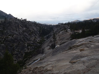 |
| Upper San Joaquin River canyon |
 |
| Camp high above the canyon |
 |
| Granite cliffs and domes above Fish Creek Valley |
 |
| Soaking in Iva Belle Hotsprings |
 |
| Fat King Bolete |
 |
| The champagne pool adjacent to our campsite |
The following day, we headed up and over Silver Pass, from the low valley setting of the hotsprings back up to high mountain meadows and lakes. The area on the north side of Silver Pass included several mountain lakes set among tall granite mountains, and we wished we had more time to explore it, but we still had many more miles to go before Bishop and only limited food stocks. As we pitched camp just on the south side of the pass near a large mountain lake, thunderstorms rolled in with wind, lightning, thunder, rain and a touch of snow. We stayed dry, but cold, and packed the tent wet the next morning, headed for Mono Creek, and eventually onto Bear Creek later that day. It was a rhythm that we had become accustomed to: pitching and breaking camp between climbing and descending in total more than five thousand feet a day. We pitched camp near the intersection for the Italy Pass route, at a beautiful falls on Bear Creek. The next morning was bright and sunny for a welcome change, and we enjoyed the great weather as we headed over magnificent Selden Pass. Unfortunately, the weather had changed by that afternoon and it started raining as we reached the South Fork San Joaquin River. The morning sun and afternoon rain was another pattern to which we had become accustomed.
 |
| Nearing Silver Pass |
 |
| Granite peaks near Silver Pass |
 |
| Storms in the distance at Silver Pass |
 |
| High alpine lakes and peaks near Silver Pass |
 |
| Camp at Silver Pass Lake |
 |
| Falls on Bear Creek near the Hilgard Branch |
 |
| High meadows near Selden Pass |
 |
| High alpine lake with Selden Pass in the background |
 |
| Granite parkland |
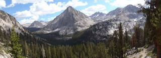
I was excited to head up the South Fork San Joaquin River, both because the area was new to me and we would soon be in the scenic Evolution Valley just north of Muir Pass. We passed into Kings Canyon National Park, all the while getting great views of the South Fork, and headed east up Evolution Creek towards verdant McClure Meadow. Evolution Creek falls to its confluence with the South Fork in a series of spectacular cascades and deep blue pools, which we gazed upon as we made the ascent. Right on cue the afternoon clouds rolled in and it started to rain lightly; the forecast we got from the ranger called for more of the same but then some clearing in the next days. We continued our ascent up the valley towards Muir Pass, pitching camp eventually near the outlet of Evolution Lake near treeline at about 10,800 feet. The granite landscape, deep blue waters of the lake, and towering peaks of Mts Darwin, Huxley, Mendel and others was simply breathtaking.
 |
| Climbing up to Evolution Valley |
 |
| Evolution Lake |
 |
| Wanda Lake below Muir Pass |
 |
| Wanda Lake reflecting the Goddard Divide |
The trek up and over Muir Pass the following day was filled with stunning high country scenery, including more high alpine lakes filled with frogs, stark granite ridgelines, and blooming wildflowers including stunning Alpine Columbine. Atop the pass, at 12,100 feet, the Muir Hut made for a great stop. We headed down the rough trail on the south side of the pass, dropping more than four thousand feet into the Kings River drainage and LeConte Canyon. We were excited to be heading up over Bishop Pass the following day, to take a break from the trail, resupply, and visit with Darren and Sarah, and also with friends Camille and Erin who were coming from the Bay Area to meet us at the trailhead. Although we had already climbed about 1,300 feet and had dropped about 4,300 feet over 12 miles, we were feeling strong and our packs were now light, so we continued up towards Dusy Basin on the west side of Bishop Pass. The following morning we completed the ascent through the scenic basin, and dropped down to be greeted and saved by our trail angel friends.
 |
| Heading up to Muir Pass |
 |
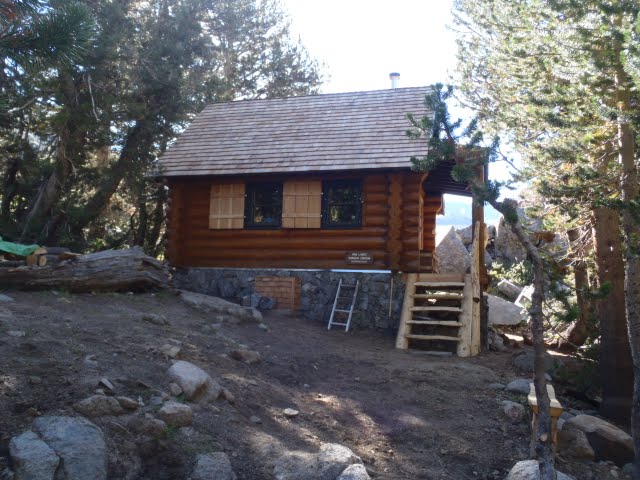
| Sierra Club hut atop Muir Pass |
 |
| Inside the hut |
 |
| Monsters along the trail |
 |
| Granite slabs and creek up towards Dusy Basin |
 |
| Looking into LeConte Canyon from Dusy Basin |
 |
| The Palisade Group from Dusy Basin |
As we devoured Las Palmas’ delicious burritos and Negra Modelos, we talked over the plans for our break in Bishop, which included going to the Mill Pond music festival, brunch at Darren and Sarah’s, and camping out for a few days. It was a welcome break from the 12+ mile days, relentless elevation changes, and the hammering that our feet were taking (Kristen had a few blisters), as well as a great opportunity to catch up with friends we had not seen for some time and enjoy some good music. The music festival turned out to be a low-key version of High Sierra Music Festival, with many more families. A particular favorite of ours was the danceable band Incendio. By Sunday morning, after two days of rest, we said our goodbyes to Camille and Erin, and Darren kindly gave us a ride back up to the trailhead. Although our packs were heavy again with 10 days of food, we felt strong after resting, and blazed over Bishop Pass, dropping just below Dusy Basin for camping.
 |
| Camped out in the Buttermilks outside of Bishop |
 |
| Brunch at Darren and Sarah's |
 |
| Mill Pond Music Festival |
The weather forecast had supposedly improved, and the following sunny day we dropped further into LeConte Canyon before heading east up Palisade Creek towards Mather Pass and the “Golden Staircase”- a series of steep switchbacks cut into the headwall of orange-tinged granite leading up to Palisade Lake. We camped just below Palisade Lake as thunderstorms developed and rain started to fall- so much for the improved forecast. Regardless, the peaks of the Middle Palisade group vaulted majestically from Palisade Lake, and we watched an incredible light show of alpenglow in the evening as the storm cleared.
 |
| Storms coming up Palisade Creek Canyon |
 |
| Middle Palisades high above Palisade Lake |
The relief as we crossed over several passes, including Mather Pass (12,100’) and Pinchot Pass (12,000’) over the next two days was diminished by the prospect of dropping back into the Kings River drainage to about 7600’. Descending through the granite parkland on the south side of the Pinchot Pass, we stopped for a great swim at Twin Lakes. Being able to swim, or at least wash off some trail dust and grime, once every other day was hugely important. The descent along the Kings continued unabated into the hot, dry lower canyon. Signs of last year’s massive snowpack were everywhere: large swaths of bent or broken aspen and pine trees at the bases of steep slopes, and in one area, a large snowbank along the river from a slide last year that had not yet melted by mid-September. We turned south to ascend towards Rae Lakes and camped for the evening.
 |
| Palisade Lakes in morning glory |
 |
| View from Mather Pass to Split Mountain |
 |
| Camp near Lake Marjorie south of Pinchot Pass |
 |
| Beautiful Lake Marjorie |
 |
| Happy campers |
 |
| High lakes near Pinchot Pass |
 |
| View north from Pinchot Pass |
 |
| Kings River Canyon |
 |
| Suspension bridge heading towards Rae Lakes |
Rae Lakes turned out to be as beautiful as I had heard, with high granite ridges and domes towering above wildflower filled meadows. We were amazed to see wildflowers such as shooting stars still in bloom- another sign of last year’s huge snowpack. Climbing up and over Glenn Pass (12,000’+), we were treated to great views, and could see the Palisade group clearly just south of Bishop Pass, about 50 miles distant. It was great to travel such large distances by foot, and see your progress at the end of the day. By this time our packs had gotten down to a manageable weight again, and we were feeling strong. The weather had also been a little nicer, with only a light afternoon shower if any, allowing us to swim/wash off in lakes or creeks. We dropped into Charlotte Creek, spying great views of Charlotte Dome, and into Vidette Meadows, dwarfed by towering East Vidette peak. We took a dip in Bubbs Creek before pitching camp near the Center Basin junction.
 |
| Meadows and Fin Dome near Rae Lakes |
 |
| Rae Lakes Ranger Station |
 |
| Rae Lakes |
 |
| Approach to Glenn Pass |
 |
| Very high happy campers |
 |
| Views from Glenn Pass, Palisades in distance |
 |
| Charlotte Lake and Dome |
 |
| East Vidette and Bubbs Creek canyon |
 |
| East Vidette |
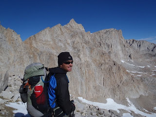
The following morning we crossed over Forester Pass (13,200’), a small notch in the Great Western Divide and the highest pass along the route. We marveled at the construction of the trail as we traversed switchbacks etched into the steep south side of the pass. Dropping into the Kern River drainage, we had noticed a new pine in the forest composition: Foxtail Pine. We camped near Wright Creek, with a great view of the alpenglow on Whitney to the south. The weather was partly sunny with many dark cumulous clouds crossing Forester Pass, but it looked like it might change for the worse, and it did.
 |
| High in Bubbs Creek Canyon |
 |
| Approaching Forester Pass |
 |
| Almost there! |
 |
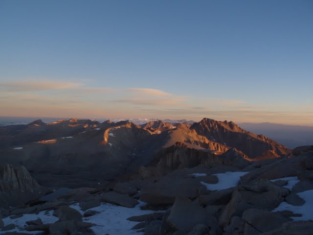
| Alpenglow on Mount Whitney from Wright Creek |
We were greeted by dark clouds the next morning, followed by intense lightning storms to the southwest over the Kaweahs and Mineral King. Although we were able to break camp in dry weather, hiking that day towards Crabtree Ranger Station and Guitar Lake at the base of Mt Whitney, we were hailed on several occasions with large pea to marble sized hail. We stopped in at the ranger station just as the couple of backcountry rangers were pulling some cookies out of their wood fired oven- the melted chocolate chips were the perfect antidote to the hail covering the ground outside. The forecast was for clearing skies that afternoon after the front passed, and leaving the ranger with content taste buds we noticed some clearing skies. However, one last passing cell caught us right as we arrived at Guitar Lake, and as we made for an overhanging boulder to shield us from the hail, a bright flash and the immediate roar of thunder quickened our pace. After the cell passed, we pitched camp with bright blue skies overhead, and planned our morning ascent of Mt Whitney. With the clear skies and western exposure, we were treated to an incredible sunset light show on the Whitney Massif above Guitar Lake.
 |
| Hail covering the trail |
 |
| Heading up to Guitar Lake, Whitney on left |
 |
| Camp at Guitar Lake below Whitney |
 |
| The last night on the trail! |
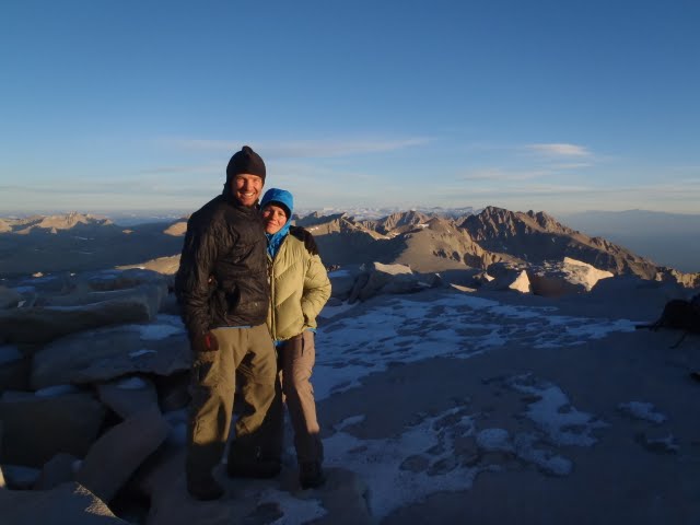
Our kind neighbors Katy and Catherine woke us at 3AM, as we had requested. The night had been incredibly cold, but we packed quickly and hit the trail under headlamp for a grand alpine start. Having spent the last week at altitude, combined with regular crossing of passes above 12,000’, we felt great ascending the western slopes of the massive peak. The darkness of the narrow, steep trail soon began to give way to the early morning light. We reached the summit at sunrise, and were once again treated to a wonderful display of golden orange colors dancing on the granite. We celebrated our ascent with some oatmeal in the summit shelter, and shared the moment with a dozen other happy folks. We headed down after an hour or so, and yielded many times to the hundred or so other hikers coming up from the east. We reached Whitney Portal by early afternoon, and, relying on our hitching Karma as we had at the start of the trip, were able to catch a ride to Bishop with some other friendly summiters.
 |
| Looking west at sunrise at the shadow of Whitney |
 |
| View north from Whitney's summit |
 |
| The summit hut at dawn |
 |
| Extremely high and happy campers atop Whitney |
 |
| Grafitti in the summit hut |
 |
| Looking down at Guitar Lake |
 |
| Snow and people ascending the trail |
 |
| Happily descending into warmer conditions |
We had hiked a total of 225 miles, finishing the JMT in 18 days total, including the days required to hike out to Bishop and back for resupply. It had been a fantastic adventure - climbing high mountain passes, gazing into deep blue lakes, meeting and enjoying the company of fellow hikers, and meandering along mountain creeks and rivers - something we would highly recommend to anyone. We had met folks on the trail who could not get that much time off at once, and had broken the trail into two 10 day backpack trips, done over consecutive summers. We also met a young guy who had decided to take 52 days to do the trek. There were soloists, guy groups, girl groups, mixed groups, and parties of all ages enjoying the journey. It was fantastic to see everyone doing the journey in their own way, in their own style, and on their own time. The extent and quality of high mountain terrain experienced over several weeks is unlike anything I had previously experienced, and I doubt I will soon forget even the details.
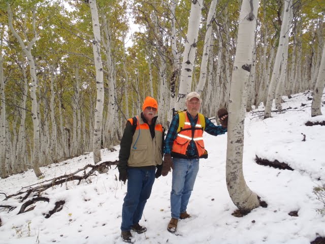
From Bishop we headed north to enjoy some hotsprings, do some climbing, kayak in Mono Lake, and prepare ourselves for the next adventure: elk hunting in Northeastern Nevada. Fortunately, hiking the JMT was some of the best physical preparation we could do for such a demanding task. Thanks for reading and stay tuned…