We could barely tear ourselves away from Liard Hot Springs. What a truly rejuvenating experience. Alas, after a quick soak in the morning, we were back on the road with more beautiful country ahead. Over the next days we would be sticking strictly to the Alkan Highway as we wound our way east over the remote Northern Canadian Rockies, south for 250 miles, and then back over the range again to the west before landing in Prince George for a re-supply. Driving the passes through the Rockies we were rewarded with sneak views of striking peaks, ever more remote wilderness, river valleys, wildflowers, and wildlife. Highlights in the northern section included the crystal clear aqua waters of Muncho Lake, stone sheep and a grizzly on the highway, the hoodoo rock formations of Stone Mountain Provincial Park, and glimpses of far off Northern Rocky Mountain Provincial Park. We drove through the area seriously wishing we had more time.
 |
| Stone Sheep |
From Fort Nelson south to Fort Saint John, the somewhat drier east side supported extensive coniferous forests intermixed with stands of aspen. The drive was a bit monotonous along this stretch but we were kept entertained by our satellite radio that was starting to get reception again (none in the Yukon and Alaska) and our trusty Milepost that provided historic tidbits primarily about the building of the Alcan. In the town of Williams Lake we had stumbled upon a great exhibit on the history of the Alcan – the route, built during World War II was initially heralded a near impossible engineering feat due to the extreme conditions and shear remoteness. A large natural gas pipeline transporting gas from the largest natural gas processing facility in North America also shared the corridor. Every once in a while a massive flame could be seen spouting out of a pipeline compressor station. In Saint John we turned west through the Peace River Valley and then the community of Chetwynd where large Hydro Projects have damned area rivers, creating jobs, and energy, but also flooding agricultural land. From the many signs on the roadside another proposed dam in the area appeared to be a bone of contention among the locals. The dam on the upper Peace River built in 1968, created B.C.s largest freshwater body nearly 700 square miles. Just before reaching Pine Pass, we could see evidence of a huge flooding event along the Pine River. One of the road crew explained there had been a really huge summer rain event just about a month before causing large scale flooding and massive damage to the highway. For miles along this stretch crews were working to clear debris and repair the road.
 |
| Chetwynd - Home of the World Chainsaw Carving Championships |
Once in Prince George (PG as the locals call it), we headed for the grocery store and Costco for a re-supply. We had learned along the way about a Canadian dish called Poutine and Graham remembered seeing it at the Costco food court in PG. Poutine is a horrendously good combination of cheese curds atop a bed of french fries smothered with brown gravy. How does that sound!? Weird I imagine, but it was oh so good! Quite the heart stopper. After a night in the PG Walmart Parking lot, we turned onto the Yellowhead highway again, this time traveling east toward the Central Canadian Rockies and Mt. Robson Provincial Park. Just out of McBride we found an amazing recreation site perched on the slope of McBride Peak overlooking the mighty Fraser River Valley below. On a hike that evening up the slope toward the old McBride lookout, we were amazed by the number of boletes mushrooms growing on the side of the slope. After my bout with mushrooms earlier in the month, I wasn’t very excited about pushing my luck, so we feasted with our eyes instead. When we got back to the van we enjoyed a new pizza concoction – ham, pineapple, and cheese with BBQ sauce on flatbread.
 |
| Poutine |
 |
| Sunset on the Fraser River |
 |
| Camp overlooking the Fraser River Valley |
 |
| Fraser River Meanders and Oxbows |
 |
| Pizza concoction |
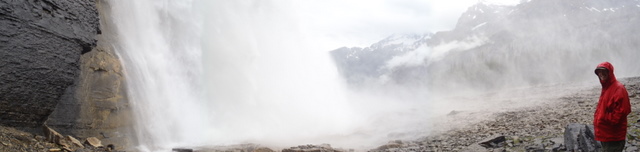
Mt. Robson (the highest peak in the Canadian Rockies at 12,972 ft) appeared the next morning in fully glory. It was so beautiful that we could not resist the opportunity to do the world renowned backpack trip to Berg Lake. We loaded our packs and hopped on our bikes. The first 4 miles of the trek could be covered by bike which allowed us to make up a little time after a late start. The trail follows the Robson River up valley to Kinney Lake, winds through the valley of a thousand falls, and around the west and north sides of Mt. Robson to Berg Lake. Due to the high volume of visitors, the park enforces a camping only in designated backcountry camps policy. We camped at the Berg Lake camp for two nights where 20 tent pads formed a little tent village. The camp (full both nights) was bustling with backpackers young, old, and international. At the shared cabin shelter we met friendly Canadians and talked over pots of cooking macaroni and cheese. Just above camp, the rumblings and moaning of the Berg Glacier could be heard throughout the day and night. On occasion large chunks of ice calved into the milky aqua waters of Berg Lake below. One morning we awoke to find a new collection of ice bergs floating all over the lake and wished we had packed cocktail fixins’ to enjoy a little thousand year old ice berg cocktail. The following day we enjoyed a beautiful day hike around the north side of Mt. Robson past the Robson Glacier to Snowbird Pass. We hiked along the Robson river right below the glacial source, on the recessional moraine, and then through lush green marmot laden meadows before topping out on the pass that overlooks the Reef Icefield. On the return journey we were lucky to see a group of about 10 mountain goats perched on rocky slopes adjacent the Robson Glacier.
 |
| Mt. Robson |
 |
| Robson River |
 |
| Valley of a Thousand Falls |
 |
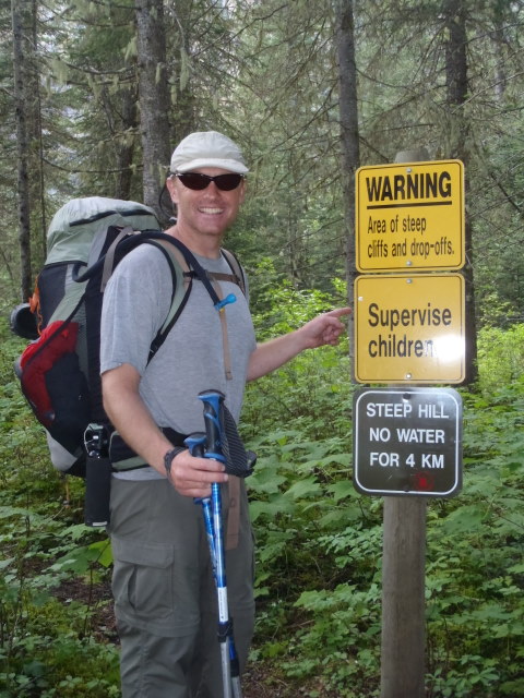
| Canadian Nanny State |
 |
| Yellow-bellied Marmot |
 |
| Gorgious views of Robson |
 |
| Mountain Goats |
 |
| Berg Lake |
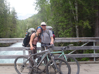 |
| Biking part of the trail |
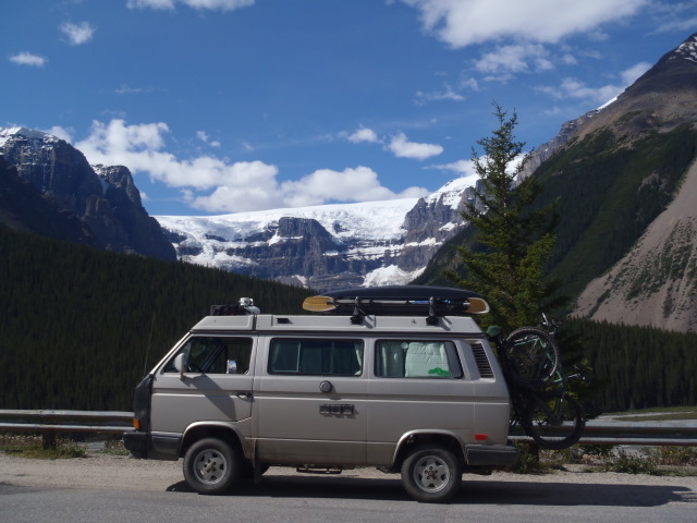
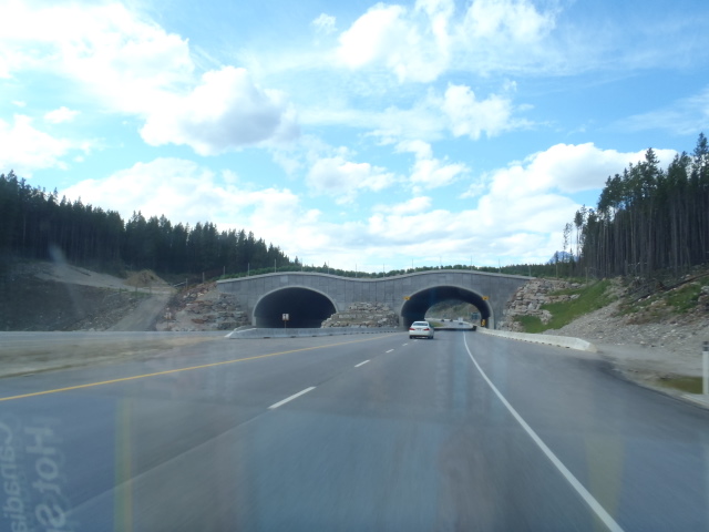
Mt. Robson Provincial Park is the western neighbor of Jasper National Park. We headed there next. Unfortunately our budget only allowed for a one day drive through both Jasper and Banff. We made the best of our time and drove south along the Icefields Parkway stopping at many of the vantage points and doing a few short walks to waterfalls, overlooks, and along Moraine Lake. The views were stunning along with the sheer number of people. Glacier clad peaks, wildflowers, and the iconic aqua lake waters were truly spectacular. In Lake Louise we picked up Highway 1 west toward Golden, passing Yoho National Park along the way. Interestingly wildlife overpasses have been constructed on the highways around Lake Louise along with an fencing to prevent wildlife-vehicle collisions. This type of wildlife infrastructure was visible all along the highway to Golden. Just east of Golden we settled in for the night at a free B.C. recreation site with a view of Wapta Falls, the largest waterfall on the Kicking Horse River. With a tip from a friend of a friend, we decided to check out the mountain biking opportunities around Golden and came away from the visitor’s center with great information on the moderate Moonraker Trails near Kicking Horse ski resort. Aside from being the most mosquito infested zone of the trip yet, we enjoyed some challenging technical biking and were then on our way to the town of Revelstoke, passing first through Glacier National Park. The towering peaks of Glacier were mind blowing. The terrain was so steep you could hardly see much of the vertical terrain above you. On the highway we passed through a series of avalanche tunnels and caught glimpses of striking Mt. Sir Donald behind us.
 |
| Elk in Jasper |
 |
| Jasper National Park |
 |
| Jasper |
 |
| Moraine Lake |
 |
| Vegetated Wildlife Overpass |
 |
| Wapta Falls |
 |
| Yum! Our favorite Canadian Cookies |
 |
| Mt. Sir Donald in Glacier National Park |
 |
| Avalanche Tunnel in Glacier |
We heard from various folks that we would most likely enjoy the town of Revelstoke. They were right. We pulled right into downtown and got to catch their music in the plaza summer series. The following morning there was a great little farmer’s market. Situated right on Upper Arrow Lake Reservoir (headwaters of the Columbia River) the community boasted a wealth of outdoor recreation opportunities including rock climbing which we did the next day at Begbie Bluffs. Graham really enjoyed lead on the climb “High and Dry” a 5.8 airy arête with lots of exposure. One of his all time favorites, he said. That evening we headed for another B.C. recreation site right on Upper Arrow Lake called Eagle Bay. It turned out to be a spectacular site right on the lake, and it was amazingly free! We were immediately welcomed by neighbors on all sides and asked to join their fires that night. Initially we planned to stay only one night but awoke to such a great scene that we couldn’t resist sticking around for two. We lounged on the beach, did some kayaking, and enjoyed a feast of rainbow trout and lingcod thanks to our generous fisherman neighbor Brent aka “the Postmaster”. It was hard to move on but we were looking forward to hotsprings and had to keep heading south.
 |
| Indian Pipe at Begbie Bluff |
 |
| Begbie Bluff |
 |
| Camping on Eagle Bay |
 |
| Brent the generous fisherman and friendly neighbor |
 |
| Thanks to Brent! |
 |
| Neighbors |
 |
| Beer-battered Lingcod |
When B.C. Hydro built the dam that damned the Columbia forming Upper Arrow Lake, they displaced about 4,000 people and also flooded the roads that connected east to west. In part mitigation included providing free transport across the lake to connect the east/west route. A ferry runs year round transporting hundreds of vehicles, log trucks, semi’s, RVs, etc. across the lake. A similar ferry runs across Kootenay Lake (reservoir) to the east and is the world’s longest free ferry ride – a 40 minute crossing. As we continued our way through the Kootenay region within the Columbia Mountains we passed through small inviting mountain towns along Slocan and Kootenay Lakes and also stopped to dip in two of the regions many hotsprings. Slocan Lake was really impressive - flanked by Valhalla Provincial Park to the West. We vowed to return to this area to boat into the many beach camps along the western lakeshore and explore the alpine lakes and mountains of the park. This region also boasts a rich mining history. The historic past is evident from the relic infrastructure along the steep drainages and the ghost towns of Retallack and Sandon. We stopped in Kaslo to walk through the historic downtown situated on the shore of Kootenay Lake. There the world’s oldest intact passenger sternwheeler, the beautifully restored SS Moyie is on display for visitors to explore.
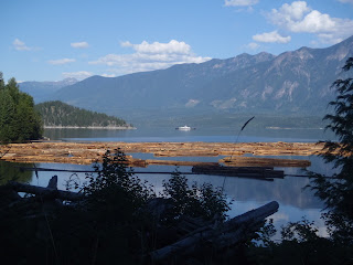 |
| timber harvest on Upper Arrow Lake with ferry in the distance |
 |
| SS Moyie |
We could have stayed a week in the area just exploring the wealth of hotsprings. The first spring we stopped to soak in, half-way hotspring, was a primitive public spring on the banks of the Half-Way River with some natural rock pools and other user maintained wooden pools. There we met nice interesting locals, many of whom were on their way home from a three day rave festival that had taken place further south in Salmo. Our second spring, Ainsworth Hotspring, was a developed hot springs resort on Kootenay Lake. This spring is famous for its horseshoe-shaped hotspring cave. Truly an awesome experience!


Southbound we followed the shores of Kootenay Lake to Nelson, onto Salmo, and across the border back into the U.S. It had been exactly two months since we first crossed the border heading north into Canada. We had seen some absolutely incredible scenes and had met great people in B.C. and the Yukon – we know we’ll be back someday. Just beyond the border crossing we spotted a couple hitchhiking with a sign indicating they were headed for Spokane. Since we had room we stopped to see if we could help. It turned out they were circus performers with a group based out of LA called Lucent Dossier who had been at the festival in Salmo. They were hoping to catch a flight later that afternoon at the Spokane airport. We hadn’t planned to go all the way to Spokane, but it wasn’t far out of our way, so we decided to give them a ride. They turned out to be great company and good folks with interesting stories to share and were absolutely elated to be getting a ride in Goldi and able to make it to the airport on time (barely!).

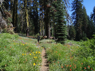
We took the opportunity to do some shopping in Spokane and were blown away by the affordable food prices! We were back in the land of the good old Grocery Outlet and cheap food and alcohol in general, that is compared to Canada. We departed the sprawling metropolis of Spokane and headed southeast into Idaho passing through a region of rolling hills laden with dryland wheat. In Idaho we settled in for the night on Forest Service land atop a nice ridge surrounded by thimble berry bushes. Before heading home we decided to do one last backpack trip in the Eagle Cap Wilderness in the Wallowa Range. Graham had visited the area a couple times before when he was studying in Eugene at the University of Oregon. I had heard great things about the area and was intrigued by what sounded like cool small communities nestled against a beautiful remote range with alpine lakes. We checked in at the Forest Service office in Joseph. Graham was surprised to find recreation in the area was much more regulated. It made more sense seeing how popular the area had become. Parking lots were loaded and campgrounds mostly full. At the Two Pan Trailhead we loaded our packs and ascended into the Eagle Cap Wilderness with much of the trail meandering along the East Fork of the Lostine River and through a beautiful glacially carved u-shaped valley. We camped between Mirror and Moccasin Lakes with great views of Eagle Cap, Matterhorn, and other surrounding peaks. The bugs unfortunately were atrocious, some of the worst we had had. That didn’t stop us from doing a great loop hike the following day up to Glacier Pass, across a slushy snowfield, up to Eagle Cap Peak, and back down to Mirror Lake. The views were spectacular, along with the weather. Hiking out the next day we hopped over Minam Pass, down to Minam Lake, and out back to the Two Pan Trailhead along the crystal clear waters of the West Fork of the Lostine River. After sharing a pint of Ben and Jerry’s oatmeal cookie ice cream and a dip in Wallowa Lake, we traversed the Wallowa Range to the east and settled in for the night at a perfect camp site along the Imnaha River. We could have stayed there a week…we’ll be back to spend a week a some point in the future. Further upstream we hiked to a legendary swim hole, called “blue hole”. The water was so cold, we didn’t get into swim, but enjoyed watching the spawning salmon that had made the arduous journey to this incredible spot.
 |
| Steak! |
 |
| Eagle Cap Peak |
 |
| Snowfield traverse |
 |
| Views from Eagle Cap Peak |
 |
| Glacially carved u-shape valley and Mirror Lake |
 |
| Camping on the Imnaha River |
 |
| Blue Hole |
Continuing our traverse of the Wallowas we stopped to peak into Hell’s Canyon, a product of the erosional forces of the mighty Snake River. Hell’s Canyon is deeper than the Grand Canyon, yet the more “gentle” slopes yield a scene less dramatic. In this arid remote northeastern corner of Oregon we passed through a couple beautiful agricultural valleys centered about tiny picturesque towns. Further south we passed through La Grande, and on toward John Day and Burns. We unfortunately had our only wildlife incident on this stretch and hit and fawn running across the road right behind Mom. Goldi escaped with only a cracked bumper, but the fawn sadly was dead. All in all were really bummed but felt lucky given the amount of wildlife we had seen on the roads the last few months and definitely glad it wasn’t a moose!
 |
| Hell's Canyon |
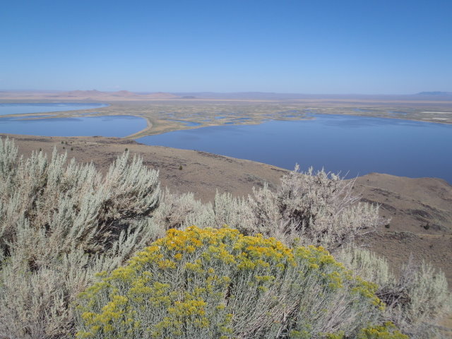
Outside of Burns we camped at a hot springs that wasn’t quite soakable but nice to check out. We spent the next day in the glorious glacially carved landscape of the Steens Mountains enjoying the panoramic views and wildflowers from our bikes. Our last night before home we camped at the hot springs campground in Heart Mountain Antelope Refuge. Highly recommend a visit here if you find yourself in south central Oregon. There are two springs. The hottest (~105°F) is in an open meadow and the other cooler pool (~100°F) we call the “champagne pool” is slightly developed, deep, and absolutely clear with tiny bubbles rising to the surface.
 |
| Coyote at hot springs |
 |
| View from atop the Steens |
 |
| Wildhorse Lake in the Steens |
 |
| Gunsight Pass - Steens |
 |
| Awesome wildflowers in the Steens |
 |
| Heart Mountain Hot Springs - the champagne pool |
 |
| Heart Lake after a big water year |
Our final day of driving was beautiful – Lakeview, the shores of Goose Lake, the Pinyon and Juniper spotted ranges of north eastern California, Susanville, the mixed conifer forests of the Lassen and Plumas National Forests, Lake Almanor, views of Lassen Peak, Indian Valley, down Indian Creek to the confluence with Spanish Creek, American Valley, and up Spanish Creek to Meadow Valley.
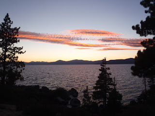
The last few weeks we’ve been home (between Meadow Valley and Reno). We’ve really enjoyed catching up with friends and family, sharing stories and photos, having some time to re-group, dancing to bluegrass music and hanging on the beach with good friends in Tahoe, meeting new babies, celebrating a friends engagement, taking good showers, sleeping in a comfy bed, and eating great mom-cooked food. Since we’ve been home we’ve also been preparing to hike the John Muir Trail and are really excited to have the opportunity to do the hike. We’re starting the hike tomorrow, the 6th of September and plan to take about 3 weeks to complete the 210 mile hike from Tuolomne Meadows to Whitney Portal. We’ll post a trip report in the beginning of October before heading out to the Jarbidge in north eastern Nevada for Graham’s elk hunt.
 |
| Hiking in the Bucks Lake Wilderness |
 |
| Lassen Peak |
 |
| Tiger Lily's |
 |
| Sand Harbor - Lake Tahoe |
 |
| Sand Harbor - Lake Tahoe |
 |
| Beach Party |
 |
| Ferry Baby Kaya |