Monday, July 18, 2011

Anchorage and the Kenai


After a few really enjoyable days along the Nebesna Road in Wrangell St. Elias National Park we continued our drive southwest toward Anchorage where we planned to meet up with our buddy Kaarle Strailey.  Kaarle, a friend from Quincy, has been living in Alaska for the last 6 years mostly based in Fairbanks but within the last year moved to Anchorage to work as Energy Coordinator for the Alaska Center for the Environment.  We were really glad to see a familiar face, to have a home base for a few days while we checked out the city and did some work on the van, and to get some tips from Kaarle about the Kenai Peninsula and surroundings. 

The drive to Anchorage was stunning even in the clouds and rain.  It was tough to drive by the turnoff for Valdez and Kennicott/McCarthy, two areas that sounded really intriguing.  We put them on the “next time” list and kept moving on as we knew there was just too much to see.  Past Glennallen the Glenn Highway leading to Anchorage offered rewarding views above tree line of the surrounding mountains, the Chugach to the South and Talkeetna to the North with large braided glacial river valleys and lakes below.  We stopped to stretch our legs at the Matanuska Glacier and enjoyed a very informative nature trail that creatively outlined glacial processes.  From here we dropped into the Mat-Su Valley, the “salad bowl” of Alaska.  Palmer in 1935 became the site of an interesting experimental Federal New Deal Program that created the Matanuska Valley Colony.   Social workers selected 203 hardy families mostly from northern counties of Michigan, Wisconsin, and Minnesota to settle in the area to develop an agricultural economy.  While the failure rate was high, many descendents still live in the area.  We were sorry to miss the record breaking vegetables showcased at the State Fair in Palmer at the end of August.

The Matanuska Glacier
Arriving in Anchorage it was interesting to find the city, the largest in the state at ~ 300,000 people to remind us a bit of Reno, kind of a diamond in the rough.  Some of the downtown area was slightly polished, but everything else was not.  The city fell victim to urban sprawl as it developed, though does have some great biking/pedestrian corridors.  The first night in town we enjoyed our first good taste of local food and beer at the Moose’s Tooth Brewery thanks to Kaarle!  Kaarle lives really close to downtown within walking and biking distance to most things and had a perfect van parking spot in his back yard.  We had a great time visiting with him and his housemates over the next few days and really enjoyed cooking in a full kitchen and taking showers!

Massive vegetables growing in the parks downtown Anchorage
For the 4th of July we were glad to be in and around Anchorage especially as we witnessed the mass exodus of RVs leaving the city for the weekend.  We did decide to venture out to the town of Girdwood about 30 minutes outside of Anchorage for an overnight to check out the music and craft festival that takes place there every 4th of July weekend.  We were sad to miss the High Sierra Music Festival this year and had been doing a lot of reminiscing and so decided a little live music might do us good.  The Girdwood Forest Fair was really a mellow little festival with great art and crafts, good music, and incredible scenic surroundings.  And it was free!  


Not quite High Sierra, but what a location!
The next day we were back in Anchorage to catch some of the July 4th festivities and to begin tackling the van battery swap.  We enjoyed a great halibut BBQ feast with Kaarle and friend Ama and fireworks at 11pm.  It was just barely dusk enough to see the fireworks display.  The next day was spent swapping out our poorly functioning auxiliary battery with a new deep cycle marine battery from Costco.  So far it has been working really well…fingers crossed.  By Wednesday we had washed clothes and stocked up on food.  We had the next week and a half to spend on the Kenai Peninsula before heading back into Anchorage for a resupply, last visit with Kaarle, and to catch up with good Reno friend Mandy who would be passing through.

Our first stop on the Kenai was the southern Johnson Pass trailhead.  The Johnson Pass trail was a great introduction to Alaskan backpacking.  Being a bit intimidated by the bear and moose environment and unsure of how we would handle backpacking in the mosquito zone it was nice to know that we would be on a trail that was well travelled, fairly open, and had established camp sites, some even with bear-proof food containers.  The 23-mile hike made for a great two night trip.  We started off skirting the shores of Upper Trail Lake then climbed up along Johnson Creek where we joined the historic Iditarod Trail.  At Johnson Pass the open views of Johnson and Bench lakes surrounded by wildflowers, and treeless peaks (some with hanging glaciers and waterfalls) was gorgeous.  We lucked out with the weather - didn’t have any rain and the mosquitoes weren’t that bad.  While there were lots of signs of bear and moose we didn’t see any.  We attribute this to our effective loud calls alternating between “hey bear”, “hey moose”, and the alphabet game.  We really had to shift our wilderness traveling modes from the norm of being fairly quiet and hoping to see wildlife to trying to be as loud as possible.  That takes a lot of energy!  We did get to see some Rock Ptarmigan and lots of wildflowers including: wild geranium, fireweed, dwarf dogwood, columbine, arctic lupine, western monkshood, chocolate lilies, and lots of cow parsnip. 
   
Upper Trail Lake

Western Monkshood

Thank goodness for head nets!


An amazing camp!
Coming out at the northern end of the trail we easily caught a ride back to the van and met some great local folks in the process.  We were able to bounce some sea kayaking ideas off of some local folks from Seward who had moved to the area in the 90s to become kayak guides.  We had decided we wanted to try a multi-day sea kayak trip with our inflatable kayak and had been dreaming about a trip on Blackstone Bay outside of Whittier, a bay we thought would be fairly protected, had a cool looking island in the middle and was surrounded by glaciers, some likely calving into the water.  Alas, they suggested we should do a shakedown trip before attempting Blackstone Bay and recommended kayaking from Lowell Point just beyond Seward in Resurrection Bay toward Caines Head State Recreation Area.  The more we thought about it, the better that sounded and we decided to turn that trip into a 3-day trip as we realized we wouldn’t have enough time to try the Blackstone trip without taking a water taxi to get there, and that was a bit out of our buget.  They also recommended good free camping along the Exit Glacier road on the way to Seward.

The free camping was excellent and provided a great starting point for checking out Exit Glacier the following day.  We had read about a 6-mile roundtrip hike that climbs up alongside the glacier and provides stunning views of the Harding Icefield at the top.  The hike turned out to be fantastic and we again lucked out with the weather!  The views were absolutely mind blowing and breathtaking!  The icefield stretched for miles and miles into the distance before us, a bitterly cold landscape of white ice and black rock extending to the farthest peaks that we could see. Below the icefield, Exit Glacier has been receding at a frightening rate in recent decades.  We later learned the glacier receded 25 feet over this last winter and roughly 150 within the last year.  It was truly a treat to observe the glacier and the ice field in its present state knowing it will likely experience considerable changes within our lifetime.  
  

Exit Glacier

Resurrection River Valley

The Harding Icefield


 The next morning we departed from Lowell Point with a heavily loaded kayak on our maiden sea expedition to Caines Head State Recreation Area.  While paddling it was comforting to see other sea kayakers out and to realize the popularity of the route.  A stop was recommended at a small beach along the way to check out a waterfall that descends the rocky steep slopes.  Beautiful!  While there was a great camp there, we decided to keep paddling onto Derby Cove where we could access some hiking trails over the next couple days.  Derby Cove was a perfectly protected spot with a great cobble beach, smooth tent pad, and good fresh water source.  There was also a public use cabin there that folks had rented out, but other than that we were the only ones camped there for two days.  The boat held up really well on our 4-mile paddle to Derby Cove.  With a few minor adjustments we would have no problem doing a longer paddle.  The only bummer is that some water comes into the boat from the seams when waves break over the bow.  Definitely more of a fair weather boat. 

That afternoon we hiked to Caines Head proper where there is an abandoned WWII Fort (Fort McGilvry).  The fort was established to defend Resurrection Bay, the ice-free deep port, and railroad terminus from Japanese attack.  You can take flashlights and walk through what remains of the underground artillery bunker.  That was really creepy!  You can also see the location of the two 6-inch guns that were mounted on top of the mountain.  In the evening we enjoyed cooking on the beach as we watched a pair of sea otters and a juvenile bald eagle also enjoying dinner.  


The main underground fortification
You can explore what remains of the fort if you have a flashlight or headlamp

Site of one of the 6-inch guns

Cooks Cove

Skunk cabbage
From Derby Cove we picked up a loop trail the following day that took us to South Beach where there were additional fortification remains and then back up the mountain through beautiful mossy spruce forest, alongside bogs and lots of little waterfalls yelling “hey bear” all the way.  We branched off on the Alpine Trail to get even higher and were rewarded with excellent panoramic views of the bay.  In the morning we packed and loaded the boat for a return paddle to Lowell Point.  The skies were absolutely clear and the wind had shifted which meant we would had a head wind going back as well L, but it was another great test paddle for the boat and it held up again really well minus the slight water seeping in along the seams.  Excited now for future overnight expeditions!  We stopped at Tonsina Creek hoping to see some Red Salmon spawning but didn’t have any luck.  We did however see a harbor porpoise.  We enjoyed walking around Seward in the afternoon, scored some great day-old baked goods, and got to meet up with Jen, a National Park Ranger in Seward (the daughter of my Moms co-worker).  We also enjoyed eating some great smoked pork sandwiches and burritos at the highly recommended Smoke Shack.  

Moss covered spruce forest
Some fantastic views of Resurrection Bay...lucky with the weather!

Landing at Tonsina Creek


What a day!

Seward is the starting point for the historic Iditarod Trail

The Seward harbor
That evening we left Seward and decided to try and find the mysterious “Waikiki Beach” on Kenai Lake that Kaarle had mentioned.  He had stayed there with friends sometime ago but could quite remember where it was.  We did find it and while there weren’t actually palm trees and pina colladas with umbrellas, it was a magical location – beautiful aqua water surrounded by lush green peaks and a small cascade draping down the opposite slope.  There was even a little “beach”.  The camp sites were glorious.  We thought about boating here, but the winds were pretty wicked and the next day we decided to move onto try and see some spawning salmon in the Russian River.  

Waikiki Beach
We saw more fisher folks than salmon.  It was amazing to see the hoards of fisher folks lined along the banks of the river.  We had heard about the “combat fishing” that occurs this time of year on many of the rivers in the area.  There had been very recent bear activity along the river.  All the fisher folks carried bear spray or guns, and some even had both.  We wondered which you would use first.  A guy we met later jokingly stated some would probably throw the bear spray in the air and then try to shoot the can of spray hoping that would do the job.  Sounded like a good cartoon image.       

We drove from there toward the community of Hope on the west side of Turnagain Arm.  We heard about a great camping spot at Mile 13 and also that there was an open mic night in town at the local bar/café.  The camp spot was again dreamy - a little cove right on the water.  Given the tidal flux that day we were able to witness the bore tide as it came in.  Turnagain Arm has the second greatest tidal flux in the world.  When the tidal flux is greatest and following an extremely low tide it is possible to see the high tide (tidal bore) come in as a solid wave.  It looked to us more like a river suddenly rushing in all at once.  It was fascinating.  We caught a little bit on film.  During this time the tide rises about 1 foot every 8-9 minutes.

In the evening we rode bikes into Hope to get some culture.  The open mic featured local singer-songwriters and the venue was a cool old tavern that served as the local bar and restaurant.  The event drew folks both locals and out of towners’ from miles around.  Hope had great character.  It was established first as a mining town and today is home to ~150 people.  Riding back to camp we passed two moose and watched a great sunset at about 11:15pm.   

Hope

Open mic night at the local tavern

Camping at mile 13
The following day we spent some time at the Portage Glacier visitor center and hiked up toward Byron Glacier.  The visitors center had great exhibits including a nice film about glaciers.  Portage Glacier too has receded at an accelerated rate and is not longer visible from the visitor’s center.  You must board a private tour boat, hike, or, as we found out later, kayak.  We had been told kayakers were not allowed on the lake and came to find out they had changed their rules just this year.  That would have been something!  Kayaking near ice bergs!  It was a little late in the day to begin this expedition, so again we put this on the list for the next visit.

Byron Glacier

Portage Lake with icebergs
We returned to Anchorage by the evening just in time to stock up at Costco and Fred Meyer for the next weeks ahead.  Knowing we’ll soon be back in the Canadian land of high food, booze, and gas prices, we definitely took advantage of a stopover in Anchorage.  Today we enjoyed catching up with our friend Mandy from Reno who flew into Anchorage and had a layover on her way to Bethel.  She’ll be flying out to her research field site to conduct field work over the next week in the Yukon River Delta.  It was perfect timing to get to see her especially with news that she and Chet are expecting a baby!  Tomorrow we head toward Denali with hopes of securing a backcountry camping permit for a couple night backpack trip this next week.  From there we’ll soon be on our way back to Canada and homeward bound with plans to be landing home by mid-August.  Time's a flyin’!  

Sunday, July 17, 2011

Northern BC and Eastern Alaska


After spending several days crossing the Interior Plateau of British Columbia and securing provisions in Prince George, we were happy to be headed for the famed Cassiar Highway. Our route west of Prince George would first take us along the western Yellowhead Highway towards Prince Rupert. This proved to be an exciting part of the journey where we re-entered the Coast Mountains and started to see some wildlife for which northern British Columbia is known. We spent the first two nights at Kager Lake/Boer Mountain, another fantastic and free forest service recreation site outside of Burns Lake. Situated in a mixed, fairly dense hardwood/coniferous forest, the site is well known for its great mountain bike trails and fishing. Here we met some locals camped out from Smithers, a pretty hip town towards Prince Rupert. They were nice enough to invite us over to their fire and offer us some fresh caught Rainbow Trout. Perhaps it was the irresistible smell of fresh trout on the grill that drew a black bear into our camp. Whatever the draw, it wanted to make quick friends with Kristen, but their dogs ended up scaring it away. As it was Father’s Day weekend, we could fish without a license, so I threw in a line but didn’t land anything. Regardless, we had a great time mountain biking, fishing, and getting a few tips for our journey from the very generous locals. 

The camp at Kager Lake/Boer Mountain

Kager Lake, a beautiful fishing spot


Fresh Rainbow Trout on the grill


We weren't the only hungry ones in the woods


As we continued towards Prince Rupert the mountains began to loom larger and larger. Outside of Smithers we hiked up to the beautiful Twin Falls that roar down a vertical headwall just below the Hudson Bay Glacier. Back on the road, I saw in the distance what appeared to be horses on steroids ambling about on a large grassy hill: we had seen our first Moose! As the mountains grew, the size and sound of the rivers coursing between them grew as well. The Bulkley and Skeena Rivers in this section were truly amazing, tearing through steep walled canyons. In the small First Nations town of Hazelton we learned the history of a historic bridge spanning the dizzying heights of the Skeena River canyon. The bridge, in its earliest incarnation in the mid to late 1800’s was a testament to Native ingenuity. The First Nations, Canada’s indigenous people, are very active in preserving their culture in this region, as was made clear by the abundance of historic totem poles, native villages, and sacred places. Just after turning north onto the Cassiar Highway we spent the night in Kitwanga, a quaint, predominantly First Nations village with free camping complete with free firewood. Kitwanga is an old village site with the significant Kitwanga Fort National Historical Park, a fortress site where a famous chief defended the Gitsxan people and territory.  Stories of the chief’s exploits are told today in the symbols adorning totem poles throughout the area.

The short, but beautiful hike up to Twin Falls


Hudson Bay Mountain and its glacier above the falls


The bridge in Hazelton high above the roaring Skeena River

The Bulkley River and its canyon

Refueling at the junction with the Cassiar Highway

Totem poles at the First Nation village of Kitwancool

Intricate designs and motifs adorned the totem poles

Salmon, beaver, frogs and other human and non-human figures


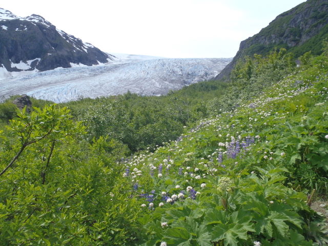
The Cassiar Highway is a relatively new road completed in the early 1970’s and now mostly paved that heads north from Kitwanga, stretching more than 450 miles with few refueling points and several great side trip opportunities to Stewart, B.C. and Hyder, AK. Its remoteness soon became apparent as wildlife sightings such as black and brown (grizzly) bears exploded in number. Although the camping at free forest service recreation sites continued to benefit us, the mosquitoes were ever present and began to increase in numbers as well. Our side trip on the Glacier Highway from Meziadin Junction to Stewart, BC and Hyder, AK was absolutely breathtaking. Another grizzly bear was spotted as we coursed through the Bear River canyon below towering mountains covered in glaciers. Fantastic blue ice falls seemed to hang suspended a thousand feet above us and the massive cone-shaped avalanche fans were a reminder of the danger here in winter. The Bear Glacier and its moraine dammed lake were very impressive, as was the Salmon Glacier, where we spent a fantastic Summer Solstice evening overlooking the entire glacier and gazing beyond to the glacier topped mountains that comprise the upper portions of Misty Fjords National Monument. We spotted an elusive pine marten darting about the glacier overlook, high in the alpine zone where they are not usually found. Although the hamlet of Hyder was only the southern tip, we had made it to Alaska by Solstice. It never really became dark that night, and the eye covers came in handy for sleeping.

We made it to Alaska... at least to Hyder, AK
 
Bear Glacier... geo-geeks will note two recessional moraines

Salmon Glacier terminus and moraine lake

Upper portion of the Salmon Glacier


Not a bad spot to spend the Summer Solstice!

Our Pine Marten friend

After returning to the Cassiar Highway from our short detour, we continued north and found more incredible and empty free forest service recreation sites, all situated on beautiful lakes. At Morcheau Lake, we enjoyed a small but tasty harvest of morel mushrooms. We also found several small birch bolete mushrooms, but, as they are not really familiar to us, did not harvest them. Passing glacially-clad mountains of incredible beauty northbound on the Cassiar, we eventually crossed the historic Stikine River, the liquid highway to the Cassiar gold fields for many miners in the late 1800’s. I had been reading John Muir’s Travels in Alaska; a great read that details Muir’s observations of this area during that time. The lenghty Dease Lake brought another incredible campsite at its northeastern shore, but the rough weather made it a little less appealing. The weather had been off and on rainy and partly sunny, but at Dease Lake a massive thunder storm lashed the area with heavy winds and rain.

Mountain views along the Cassiar Highway

More mountain views and an airstrip to access the remote area

Our campsite at Morcheau Lake

What's that buzzing sound?

Our camp at Dease Lake in the afterglow of the evening thunderstorm

Continuing northward after having crossed the continental divide south of Dease Lake, we planned to kayak in Boya Lake Provincial Park. Boya Lake is an incredibly beautiful, glacial lake whose colors are reminiscent of Lake Tahoe. The clear sunny day was a perfect match for the color of the water. We kept thinking that it was like Lake Tahoe with half the people… scratch that, none of the people! There were probably more beavers in the lake than people, and their handywork could be seen on nearly every treeless south-facing slope. We first wondered if these areas were clearcuts, but upon landing saw all of the chewed stumps. Several beaver lodges and dams were evident along the shores and bridging narrows between different arms of the lake. It was a fantastic day, and we were happy to make use of the inflatable tandem kayak that fits perfectly in our bus, but had not been used since Olympic National Park.

Kayaking on Boya Lake

Precipitated calcium carbonate on the lake floor creates brilliant colors

Just like Tahoe, but with beavers instead of people

Beaver dam between two sections of Boya Lake

Southern slopes devoid of trees


That night we camped along the Dease River at another great forest service recreation site, although this one was different: it was full of people! It appeared to us that people had been set up here for some time and may have been living here. Many of them appeared to be First Nations folks, and several trucks pulled in loaded with buckets in the back. Strange we thought, but didn’t pay much attention to this as we were anxious to explore the 35,000 acre fire that had happened the year before and see if we could find some morels. The next day, as we drove into the burned landscape dotted with makeshift camps and vehicles scattered along the roadside, and noticed all of the stooped over people in the woods carrying buckets, it all made sense. This was a gold rush of sorts, and there was money to be made by anyone who could cut a morel mushroom from the ground, put it in a bucket, and bring the harvest to a buyer! Fortunately, everyone was very friendly, showed off their harvest with pride, and graciously complimented us on ours. As we were negotiating with the buyer over our last harvest, a young man hitchhiking from southern BC to Yukon Territory told his ride spur of the moment that he would stop here for several days to pick and make some money- he had never harvested mushrooms before. Over two days we harvested about 50 pounds of morel mushrooms and were able to sell all of it. With Canadian gas prices running in excess of $6 per gallon, this was a good thing.

Not your typical migrant ag worker couple?

The mushroom camp processing 100's of pounds of morels

We had contemplated staying longer at the mushroom camps, but harvesting had begun to feel strangely like work. While it was great work involving hiking in the woods and gathering food, it was also hard work as a migrant agricultural laborer, and my back felt like it. Reaching the northern end of the Cassiar, we turned west onto the Alaska Highway, headed towards Whitehorse, where we would resupply before carrying on through the Yukon Territory. The landscape had changed somewhat, with gentler mountains replacing the rugged terrain of the Cassiar. The wildlife continued to amaze us, as we saw porcupine and more black bear. We camped one last night in BC at yet another beautiful, free BC campsite right on the shores of Morley Lake.

Driving on the Alaska Highway towards Whitehorse brought some amazing scenery, including several large lakes and rivers. We passed through Teslin Lake and met some folks who were about to embark on an amazing boat trip down the Teslin River and onto the Yukon River for six weeks! Whitehorse was a great little provincial capital with most of the conveniences of modern civilization in a very scenic setting, except we had a difficult time getting online to research the rest of our journey. We had been debating backpacking either in Kluane National Park in Yukon Territory or continuing on to Wrangell-St Elias National Park in Alaska. Eventually, we decided that we would pass through Kluane and try to spend time in the northern part of Wrangell. Although we had had a difficult day in Whitehorse and were in poor spirits, two guys at the lake where we cooked dinner raved about our bus, how fantastic our trip sounded, and exclaimed that we were living their dream. All we needed was a little perspective as we pulled back onto the Alaska Highway, the evening light shining on the strikingly beautiful St Elias Mountains.

The St Elias Mountains in Kluane National Park

Evening light of the massive peaks, though this was just the front range

Massive Kluane Lake, mountains and Lupine wildflowers in full show

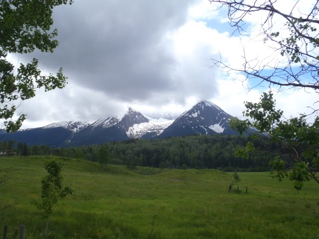
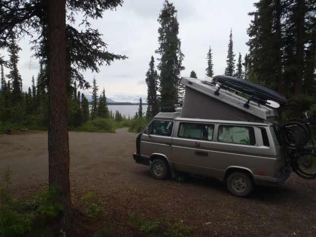
We camped north of Kluane Lake that night at a rest area. We didn’t sleep up in the pop top that night, not on account of the weather, but because we had seen a gigantic grizzly bear grazing about ¼ mile away. The following morning we dealt with a nasty section of road before crossing into Alaska. The road in this section, although mostly paved, is heavily damaged from frost heaves, and has large rolling dips (speed-bumps) and sections of uneven road surfaces. We passed into Alaska at Beaver Creek and passed through the Tetlin Wildlife Refuge, an area of rolling green hills and short spruce trees dotted with thousands of shallow lakes (aka mosquito maternity wards). We refueled in Tok before turning southwest towards Wrangell St Elias National Park, where we had decided to spend several days on the Nebesna Road. We had considered backpacking, but there aren’t really any trails in the park, and we thought it better to just do some day hikes to get our feet wet, literally and figuratively. Unfortunately, the weather was mostly cloudy and obscured most of the higher peaks such as Mount Wrangell and Mount Sanford, but we could see massive glaciers flowing through deep valleys on their lower flanks. We enjoyed a day hike up over spongy ground with stunted black spruce trees up to a public-use cabin several miles up Caribou Canyon, and ended up camping at a nice roadside site above Twin Lakes for several nights.

Alaska!

Hiking the Caribou Creek trail; Alaskan headgear mandatory
The public use cabin at Caribou Creek

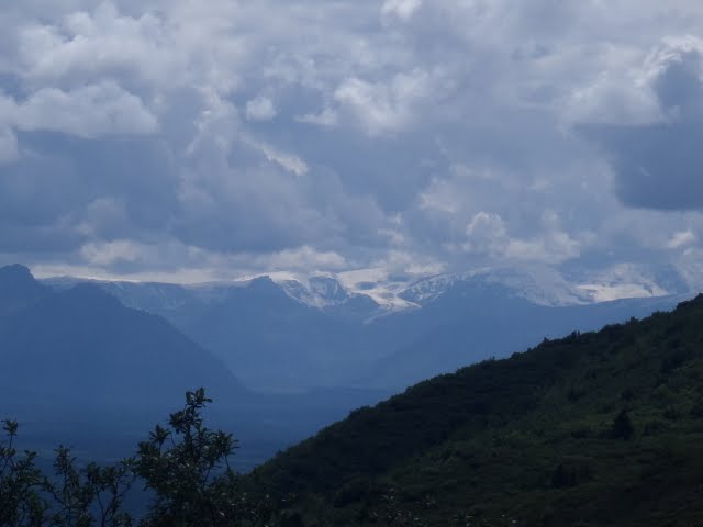
Glaciers flowing from the slopes of Mount Sanford in the distance

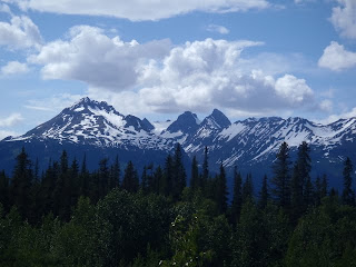
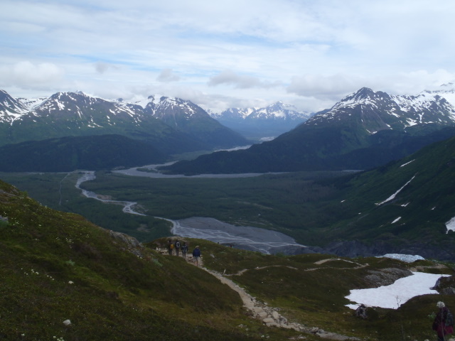
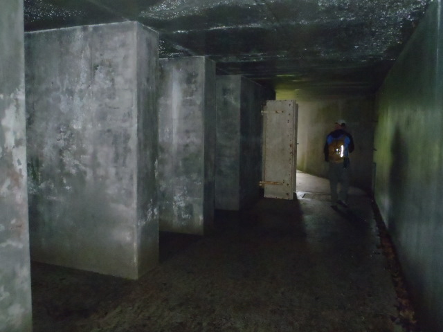
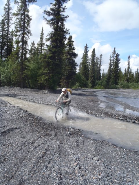
Our last full day in the park was spent biking and hiking up to the old abandoned mine at Nebesna. The weather had cleared somewhat, and we enjoyed an exciting 36 mile ride on the rough dirt road with several stream crossings, passing through a landscape of high, glacially sculpted mountains of volcanic and metamorphic rock. We explored the abandoned gold mine perched on a mountainside overlooking the scenic Nebesna River just below where it emerges from the glacier of the same name. It appeared that the mine was visited only infrequently, and there we no tourist facilities or interpretive signs to speak of. The old mine buildings were mostly still intact, and even some of the original receipts (typed and dated 1946) from the US General Land Office for payment on the mining operation were scattered on one of the desks. Back at camp, we were weary after a long day of riding and exploring. We pulled out our outdoor shower and showered above Twin Lakes… we really enjoyed the hot water that night. The next morning we departed for Anchorage for the 4th of July weekend, ready for some time in civilization and looking forward to visiting Kaarle, a friend of Kristen’s from Quincy.

Negotiating a stream crossing of a braided channel

Views from the Nebesna Road

An airstrip at the end of the road, Wrangell Mts. in the distance

Abandoned Nebesna Mine

The mine and Nebesna River Valley in the distance

Some structures were best left alone and unexplored

KEEP OUT!? No problem

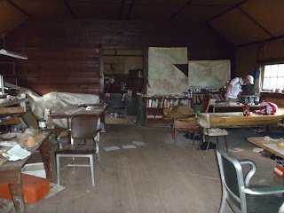
Other structures were fine and had historical documents laying about

Panorama of the Nebesna Mine looking east