Leaving Anchorage for the Alaska interior was a move filled with trepidation. There were supposedly even more mosquito hordes, and, despite our years of combined backpacking experience, we were uncertain of our ability to take on a trek in Denali National Park. Adding to the sense of anxiety is that you don’t really know where you can go in the vast park until you get there in person and apply for the permit. These aspects of our planned trip weighed on our minds as we travelled north in a driving rain up the Parks Highway from Anchorage while ominous clouds obscured the Alaska Range and Denali itself.
Fortunately we arrived at Denali National Park early in the morning after sleeping near Broad Pass, one of the lowest passes in the Alaska Range. The landscape had changed from the forested hills and glaciated mountains of the Kenai and Anchorage area to broad, rolling hills of the Alaska Range frontcountry. The rivers – the Kashwitna, Susitna, Chulitna, and Nenana – were all still impressive glacial rivers, but the vegetation had changed to tundra, low shrubs, and scraggly spruce trees, especially in the rain shadow on the north side of the Alaska Range, where the bulk of Denali National Park is located.
To say that DNP is a behemoth is not an exaggeration. It is the size of New Hampshire; a fact not lost on us as we perused the backcountry access units on the large, detailed map that covers the better part of two entire walls in the Backcountry Access Center. We were lucky to get a permit starting the following day for two nights in units that we had researched earlier online – units that are in a mountainous area just northeast of the Denali Massif. As in other popular backpacking areas (such as the High Sierras), DNP limits the amount of people that can stay in each unit per night with a quota system. Apart from that, understanding backcountry travel in DNP requires a paradigm shift. First, there are no trails. Second, there are no established camps. Third, and perhaps most important, there are numerous large animals moving on the landscape, some of which will gladly have you for dinner if you screw up. This is all explained very clearly in an instructional video, illustrated with techniques for avoiding confrontations with grizzlies, such as eating back to back or facing each other so that you can scan the horizon for them while you eat. While a bit frightening, this at least made sense. The concepts of not walking in single file (so as to not create a trail) and not camping in a place that appeared to have been camped in previously (so as to not establish a camp) seemed to counter everything that we had been taught about backpacking and leave no trace in general. There are also no bridges crossing the many rivers and creeks and if you need to cross one, it is on you to find the best place to cross and get to the other side. Denali is a very, very, wild place, and the idea is to keep it so. The sense of adventure was palpable as we left with our permit in hand.
Since our permit was valid for entry the following day, we secured tickets for our shuttle ride into the park and then decided to spend the rest of the day at the visitor center and other easily accessible parts of the park. DNP has only one ~90 mile road into it, and only park shuttle buses (basically glorified school buses) may drive on this road. While this might seem restrictive, it only seemed to enhance the feeling of adventure, as if we were going on a safari tour.
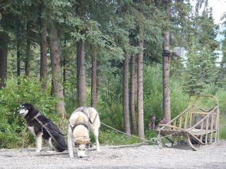
Enough waxing about our mindset, you all probably want to see some photos! Perhaps it was us who also needed some fluff, so after going to the excellent visitor center, we went to the sled dog demonstration, where one can pet nice, cuddly creatures and forget about grizzlies. During winter, when snow covers the landscape and temperatures drop in the -40’s F range, these dogs are all used to patrol the park via dog sled. While the dogs are not of any particular recognized breed, these Alaskan sled dogs all have long legs, massive paws, great strength, and high intelligence – all characteristics great for winter snow travel. Members of a particular litter are all named after a specific theme relating to Denali natural history (Tephra and Lava, or Chinook and Coho, for example). We also visited the Murie Science and Learning Center, where current research projects in the park are laid out in greater detail. It is named after Adolph Murie, the pioneering Denali biologist/ecologist who researched fauna of the arctic/sub-arctic, and who argued against road expansion and improvement into the park. One fascinating project examined photo series of particular landscape elements, such as glaciers, over time. At the risk of stating the obvious, Denali is part of a very dynamic landscape where the only constant is change.
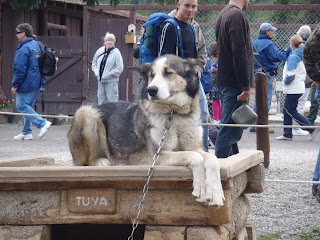 |
| Tuya looking regal at his post, note the huge paws |
 |
| These dogs take the summer off, but work hard in winter |
 |
| The sled geared up and dogs harnessed for the demonstration |
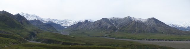
We headed out of the park to camp for free and pack our backpacks that evening, making sure that we were close enough to the park to return for our 6:55 AM shuttle departure. Just outside the park, we passed through a heavily commercialized strip on the highway, derisively dubbed “glitter gulch” for the ubiquitous presence of cheap kitsch cluttering the tourist trap. Thanks in part to the efforts of folks like Murie, the views from the shuttle in the morning could not have stood in sharper contrast. The park road is paved for the first 15 miles, and traverses some short forests of spruce and hemlock, interspersed with braided channels filled with milky water that drains from the glaciers in the mountains. After the pavement ends at Savage River, the road passes through some rocky, steep mountains where we got our first views of some wildlife: Dall Sheep. The immensity of the landscape became obvious as we stared across vast alluvial outwash plains sloping down from the foothills of the Alaska Range to the south. The vegetation became shrubbier, and occasionally denser along tributary channels of the mighty rivers: the Teklanika, the Toklat, and the McKinley. The braided channels themselves were up to a mile wide… on a scale that rivaled anything I had seen before. The park landscape reminded me of a wetter Death Valley, with much larger mountains. Wildlife became abundant as we observed numerous Dall Sheep and Grizzly Bears. We had lucked out with the weather, and as the peak of Denali came into view against the backdrop of a blue sky, we were simply stunned. The Denali Massif is of a Himalayan scale, with many side peaks and ridges in the foreground that would be impressive just by themselves. All of the peaks are draped with huge glaciers that tumble through ice falls and flow into rivers of ice, the snouts of which extend from the mountain front in varying lengths.
 |
| The Teklanika River and its wide, braided channel |
 |
| Vast alluvial plains sloping from near the Polychrome Mountains |
 |
| Our first view of Denali with the narrow, windy park road |
 |
| Dall Sheep perched atop a rocky ridge |
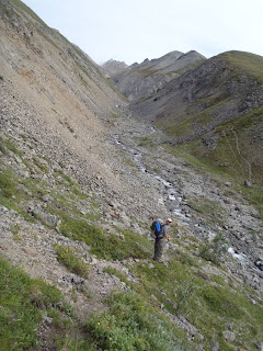
We got off the shuttle at Eielson Visitor Center, not really knowing where we should start, since there is no trail. The backcountry ranger had suggested we might start there and make our way up the drainage below. The landscape is wide open with low tundra, so we decided to scan the landscape just before heading down to the braided channel below. As we glassed the landscape, we noticed three grizzly bears grazing up on the terrace opposite us. At a half mile away, they were a safe distance, and appeared to be staying put, so we decided to continue down but to keep an eye on them as long as we could. The problem was that as we descended, we lost sight of them. Reaching the channel, we crossed one of its braids and continued up the gravel highway. Just as things appeared to be going well, we noticed the three grizzlies perched on the edge of the terrace, and had began to run downhill towards the channel that we were in. It appeared to be a sow with two several-year-old cubs. We watched in amazement as their massive bodies effortlessly sprinted downhill at incredible speeds. They were still at a safe distance of about ¼ mile, but we decided to move up the opposite bank again and then upstream, which meant that we would be in thick vegetation for several hundred yards as we bypassed them. We struggled through the vegetation, loudly calling out “Hey Bear!” as we proceeded, hoping that they would at least hear us if they had continued across the channel and into our path. Relieved, we gained the terrace and ascended the tundra slope, noticing that the grizzlies had stopped in the channel about two hundred meters below us. This was a wild introduction to the Denali wilderness! (All these images should be clickable for a better view)
 |
| Our backpack route up the drainage and left towards the snowy ridges |
 |
| We were lucky to have such great weather with views of Denali |
 |
| The three bears at about 250 meters... Yikes! |
We continued up the gently sloping tundra headed for a mountain pass about five miles distant. The hike was pleasant and we regularly scanned the landscape ahead for bears and other wildlife. After about four miles and 1200 feet of elevation, we reached an unnamed, beautiful, alpine lake with a lovely green hue, and camped above it. One a neighboring ridge we could see a herd of Dall Sheep grazing on the steep slopes. Best of all, from our tent we could see the twin summits of Denali!
The following two days were also clear with great views of Denali, and apart from a few route finding difficulties, we had a fairly straightforward backpack trip in Denali. Our final route from Gravel Mountain took us on a sharp knife-edge ridge frequented by Caribou, several of which we saw as we descended. As we headed back to the road on our last morning to catch an early shuttle bus to see the rest of the park, we had to evade a grizzly once again. This grizzly was a large adult male, and as he dug like a backhoe for ground squirrels next to the road, we decided to head the opposite way another ½ mile to another point on the road for the shuttle. Further into the park, the Muldrow Glacier, McKinley River and Wonder Lake were impressive sights. So too was a pair of moose and the caribou carcass of a recent wolf kill that we had missed earlier that morning. Denali certainly is a wild place, and we departed the park feeling alive and invigorated.
 |
| Views across the drainage and tundra slopes towards Denali |
 |
| Kristen resting on tundra slopes admiring Denali |
 |
| As we got higher, the terrain got a bit rougher |
 |
| On a scree slope on our route |
 |
| Panorama of adjacent ridge (left), our tent (center), and lake (right) |
 |
| Close up of Denali from our tent |
 |
| As the light changed, we were treated to a beautiful show! |
 |
| On a ridge near camp |
 |
| Our private alpine lake with views of Denali |
 |
| The colorful volcanic rocks stood in sharp contrast to the glaciers on Denali |
 |
| View as we ascended from first our camp |
 |
| Kristen scanning the landscape atop a ridgeline near Gravel Mountain |
 |
| We explored several ridgelines, enjoying the views |
 |
| Scouting the exit ridgeline to see if it "would go" |
 |
| Caribou also traveled these ridgelines |
 |
| Back on the shuttle bus, we saw a moose with two calves |
 |
| The receding, vegetated terminus of the Muldrow Glacier |
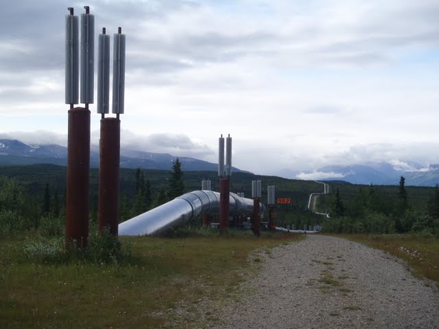
Following Denali, we headed for a highway of the same name that traverses the countryside just south of the Alaska Range east of the park. We spent two days on this “driveable Denali”, enjoying the impressive glacial landscapes of deep, broad valleys and ice-clad peaks, and harvesting some fantastic blueberries on an esker. For the non-geodorks, an esker is a winding ridge of sand and gravel that formed in a drainage underneath a glacier. We really enjoyed the fresh blueberries, having them with yoghurt, in pancakes, and on sinfully simple Nutella concoctions for breakfast. Regardless of what we ate, our eyes always feasted on the magnificent views of our campsites and around every turn of the road. As we headed north towards Delta Junction, the Alaska Pipeline’s incongruous form stretched across the vast landscape.
 |
| The vast tundra and stunted spruce forest from our camp on the Denali Highway |
 |
| The Alaska Range continued to loom in the distance, though it was partly cloudy |
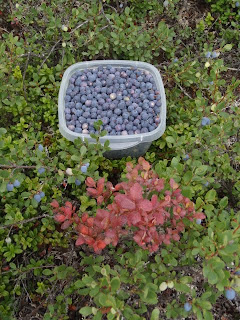 |
| Fresh blueberries harvested on the esker |
 |
| View of the partly obscured Alaska Range to the north |
 |
| Fireweed and the Denali Highway atop an esker |
 |
| Goldi was getting some use on the 130 mile gravel road |
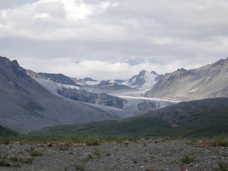 |
| View of the Gulkana Glacier near Paxson |
 |
| Fresh blueberry pancakes |
 |
| Fresh blueberries with Nutella on top of toasted English Muffins |
 |
| The Alaska Pipeline |
We were excited to be heading northeast towards Yukon Territory and Dawson City via the Top of the World Highway. The partly paved highway is known both for its grand views atop a network of ridgelines that snake northward and its rough surface conditions. We were lucky to find some delicious Bolete (both King and Aspen varieties) mushrooms our first night. We made sure to stop in the remote hamlet of Chicken before crossing the border back into Canada. Back in Canada, the road was back to pavement, but there is still no bridge to cross the Yukon to reach Dawson City. So we took the free ferry, an exciting part of the adventure. Dawson City turned out to be a very cool place where the streets and buildings ooze history. Similar to a less-polished Virginia City, NV, complete with wooden sidewalks, the place is filled with characters, such as the Big Lebowski (Jeff Bridges movie character) look-alike with whom we chatted at a coffee shop. Like many in Dawson City currently, and numerous before him, he’s there digging for gold.
 |
| King Bolete and Aspen Bolete mushrooms |
 |
| Downtown Chicken, Alaska |
 |
| Alaskan take their firearms and drinking seriously |
 |
| Goldi getting dirty atop the Top of the World Highway |
 |
| Waiting for the ferry to cross the Yukon River into Dawson City |
 |
| The streets of Dawson City, probably not much different from many years ago |
 |
| Dilapidated buildings in Dawson City leaning from permafrost |
From Dawson City, we headed for our most northerly destination. Travelling up the Dempster Highway towards Inuvik, we had planned to backpack in the remote and incredibly scenic Tombstone Range. Unfortunately, the night before arriving, Kristen’s stomach took issue with the Aspen Bolete fettuccine we had made (some people unfortunately can adversely react to these delicious morsels). Although the sharp, dark granite peaks beckoned in the distance, partly because of the on and off rain and chilly temperatures, combined with Kristen’s fragile condition, we decided it would be best to save the Tombstone Range for the next time we make it to the far northern reaches of our continent, to this vast and raw landscape of cold, where the spindly trees stunted by permafrost give way to subarctic low shrublands.
 |
| Looking for the pot of gold just after departing Dawson City |
 |
| The striking peaks of the Tombstone Range in the distance |
Having passed the most northerly point of our travels, we were somewhat relieved to be headed south. We spent several days heading down the Klondike Highway, noting the impressive geological features such as the Tintina Trench, and exploring facets of the Yukon River. Before completion of the Klondike Highway in the 1950’s, the river was the main transportation corridor, which was not without obstacles, such as Five Finger Rapids. We spent an afternoon in Whitehorse before departing Yukon Territory, but wished we could have taken a bit more time in this northern city.
 |
| The Tintina Trench, a massive geological feature and avian flyway |
 |
| Five Finger Rapids on the Yukon River |
What was the rush?, you might ask. While we have the luxury of a very flexible schedule, we had spent a fairly long time in the cold Alaskan and Northern Canadian wilderness, and were anxious not only to return to some warmer climes (we’ve only worn shorts once so far this summer!!!), but also wanted to visit the famous Liard Hotsprings in Northern British Columbia. On the way southbound just before Liard, we witnessed a herd of Bison about 50+ in number. Liard Hotsprings is a provincial park, but the springs themselves are developed only in a minimal sense. The springs are absolutely beautiful and we soaked several times from the late afternoon to the following morning. We also happened to meet some great folks, Pam and Tina, who were headed back to San Diego after similar adventures in Alaska. Chatting with them about home - California and points south - at their campfire while enjoying their delicious smores, only reinforced our sense of pining for the sunny lands down south with which we are so familiar. Despite having a great trip, or perhaps because of it, we were happy to be southbound.
 |
| Large Bison from the roadway near Liard Hotsprings |
 |
| Fresh raspberries and blueberries in pancakes.... Yuuuummmmmy! |
 |
| Beautiful, natural Liard Hotsprings |